UPDATE: AROMA-VOC in Collaboration Between the University of Houston and Baylor
Comments Off on UPDATE: AROMA-VOC in Collaboration Between the University of Houston and BaylorThe University of Houston and Baylor University are adding AROMA-VOC to their mobile monitoring capabilities in the summer of 2021. A team of researchers and their students, including Dr. James Flynn from University of Houston, as well as Dr. Rebecca Sheesley and Dr. Sascha Usenko from Baylor, has been studying the air quality in Houston and El Paso, Texas over the past couple of years. Of particular interest is how different sources of volatile organic compounds (VOCs) contribute to ozone levels in these regions. They are adding AROMA-VOC to mobile monitoring campaigns to identify and quantify sources of benzene, toluene, ethylbenzene, and xylene(s) (BTEX). AROMA-VOC is a flexible, real-time chemical analyzer with part-per-trillion detection limits of benzene and other VOCs.
Mobile, lab-quality hazardous air pollutant monitoring in Denver
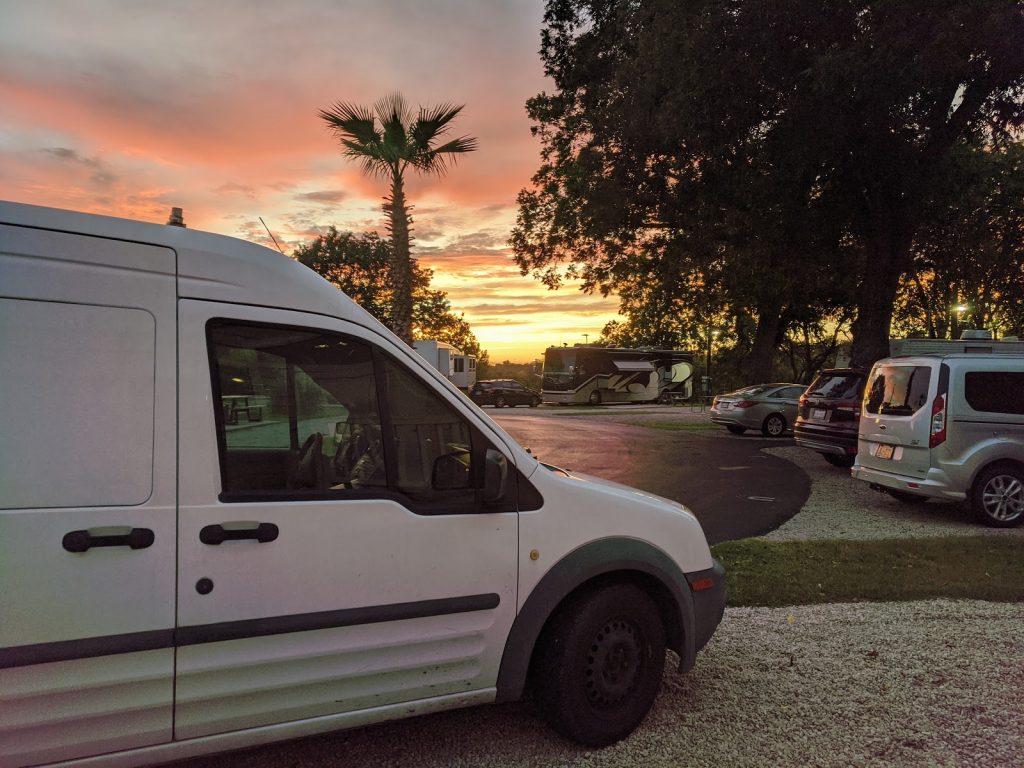
Comments Off on Mobile, lab-quality hazardous air pollutant monitoring in DenverAROMA-VOC was recently in the Denver area, collecting mobile air quality data from a rental minivan. After the instrument was uninstalled from the Colorado Air Monitoring Mobile Laboratory (CAMML) on March 8th, Entanglement’s CEO Tony Miller and Senior Account Executive Aurelie Marcotte were able to re-install the tool and begin mobile monitoring operations within 30 minutes
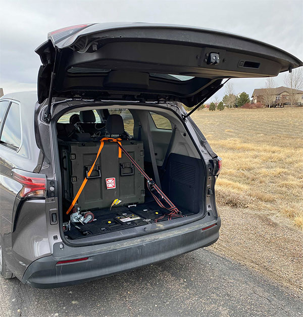
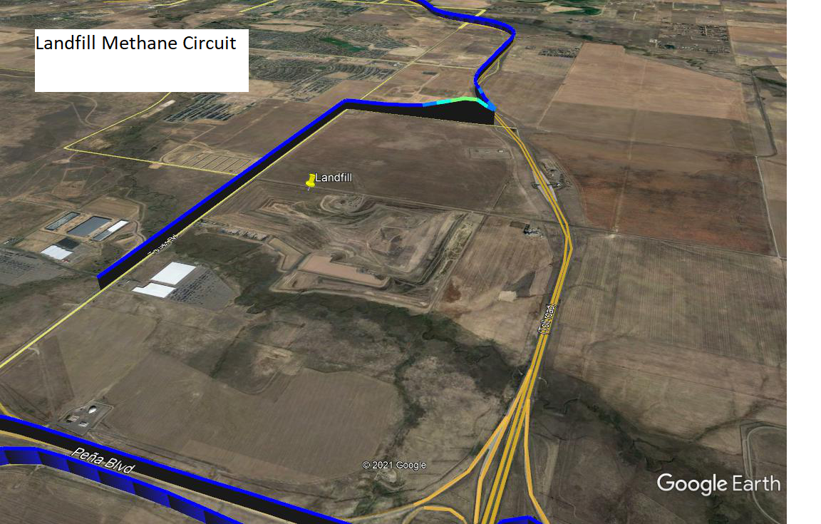
AROMA-VOC collects speciated, lab-quality data on hazardous air pollutants (HAPs) in the field or in a vehicle, with part-per-trillion detection limits for most compounds. Using AROMA-VOC in RapidScan mode, the instrument took real-time measurements continuously during the drive, which included passes near an oil and gas well pad, landfill, wastewater treatment plant, and oil refinery.
AROMA-VOC data chemically identified the well pad through a distinct alkane spike, and found an increased methane signature near the landfill, with both findings consistent with wind direction. The refinery had an overall elevated alkane signature with significant increases near holding vessels and fill stations.
Running AROMA-VOC in RapidScan mode provides class compound identification down to ppb levels in seconds, facilitating real-time identification and characterization of areas of interest. These areas can be then further investigated via the instrument’s LabScan mode, which is able to separate and quantify compounds down to part per trillion levels.
Contact us to learn more about how AROMA-VOC can turn any vehicle into a mobile air monitoring laboratory in less than an hour. No buildout required.
UPDATE: AROMA-VOC Onsite with the Colorado Department of Public Health and Environment
Comments Off on UPDATE: AROMA-VOC Onsite with the Colorado Department of Public Health and EnvironmentAROMA-VOC is now onsite with the Colorado Department of Public Health and Environment for a one-month combined fixed and mobile study on oil and gas operations in the Denver area. AROMA-VOC brings unique capabilities for state and municipal air quality professionals to rapidly respond to, monitor, map, and quantify hazardous air pollutants, such as benzene and 1,3-butadiene down to part per trillion detection limits in a vehicle. The robust design of AROMA-VOC enables large geography, lab-quality assessments without requiring costly mobile laboratory buildouts or extensive training. Contact us to learn more about how AROMA can help you improve your air quality response capabilities.
DATA: Performance Validation of AROMA-VOC in 30-Day Autonomous Remote Study
Comments Off on DATA: Performance Validation of AROMA-VOC in 30-Day Autonomous Remote StudyIn a study showcasing the ability of AROMA-VOC to continuously gather high-quality data in remote locations, the instrument showed excellent agreeability with a Bay Area Air Quality Management District GC-FID over the course of 30-days. Operating completely autonomously, AROMA-VOC was configured to co-sample with the GC-FID and performed daily calibration verifications without any operator intervention. The analyzer showed no outliers or data drift during the study.
UPDATE: Colorado Department of Public Health and Environment to Deploy AROMA-VOC
Comments Off on UPDATE: Colorado Department of Public Health and Environment to Deploy AROMA-VOCThe Colorado Department of Public Health and Environment (CDPHE) is working with Entanglement Technologies to gain understanding and data on refinery emissions and their temporal and spatial variations in the Centennial State. Using AROMA-VOC, the CDPHE will be able to measure key hazardous air pollutants (HAPs) frequently used in the petrochemical industry such as BTEX and 1,3-butadiene down to part per trillion detection limits in both a long-term fixed study and a mobile, large geography assessment. The highly stable analyzer core of AROMA-VOC facilitates long-term remote deployments with fully remote instrumentation operation for the fixed monitoring portion of the campaign. The mobile monitoring campaign, using the same AROMA-VOC, will explore spatial variations of the hazardous air pollutants, and will allow the CDPHE to gather critical data over hundreds of miles on the potential exposures of these pollutants to nearby communities.
UPDATE: AROMA-TOX to Become Part of the Toolkit in Harris County, Texas
Comments Off on UPDATE: AROMA-TOX to Become Part of the Toolkit in Harris County, TexasHarris County Pollution Control Services in the Houston, Texas, area has purchased the AROMA-TOX, a high-quality real-time chemical analyzer, to provide ppt-level data in the field on some of the most hazardous chemicals frequently used in the petrochemical industry. This effort is part of significant investments Harris County is making in air quality monitoring capabilities as part of an initiative to bring real-time data to its residents during storms and disasters. In light of the substantial increase in hurricanes and tropical storms in the Gulf in 2020, Harris County Pollution Control Services has been focused on expanding its rapid response capabilities with regards to monitoring pollutants from its heavy industrial activity. These include hazardous air pollutants (HAPs) such as benzene, hydrogen sulfide, 1,3-butadiene, and hydrogen cyanide. With AROMA-TOX, Harris County Pollution Control Services will be able to effectively and rapidly deploy and respond to industrial leaks and accidents and will further increase its ability to protect the surrounding communities.
Editorial: Taking Ozone Investigations Down to Ground Level in San Antonio
Comments Off on Editorial: Taking Ozone Investigations Down to Ground Level in San AntonioThis summer has been particularly hectic for public health investigators around the world. Their diligent efforts to trace, understand, and work on containing the unprecedented global health pandemic have taken countless hours. However, while this threat still looms large, other public health threats continue to persist that require diligence and attention as well. One such major threat to urban regions is ground-level ozone, which is where the Entanglement Technologies team comes into play.
Ozone is a colorless, highly irritating gas. When in the upper atmosphere, ozone is an extremely important blanket layer which absorbs much of the sun’s ultraviolet (UV) radiation. However, when ozone is present at ground-level, it damages cells in the lungs, aggravating asthma, chronic lung disease and a variety of other respiratory illnesses. It is considered a “secondary” pollutant since it is produced when two “primary” pollutants react in sunlight. The primary precursors of ground level ozone are nitrogen oxides (NOx) and volatile organic compounds (VOCs). Ground-level ozone has an enormous health impact. By some estimates, it will be responsible for $580 billion in increased health costs and 2 million premature deaths by 2050.
Recently, the Entanglement team spent 10 days in the field in San Antonio, Texas, in order to help the city better understand the sources of ground-level ozone’s primary precursors, NOx and VOCs. This type of data is especially useful for regulators and air-monitoring agencies of counties designated with nonattainment status by the EPA. By way of the Clean Air Act, the EPA is required to set National Ambient Air Quality Standards (NAAQS) for criteria pollutants, one of which is ground-level ozone. Currently, ozone standards for attainment status are set at below 70 parts per billion (ppb), and the EPA has recently proposed to maintain this level through 2025.
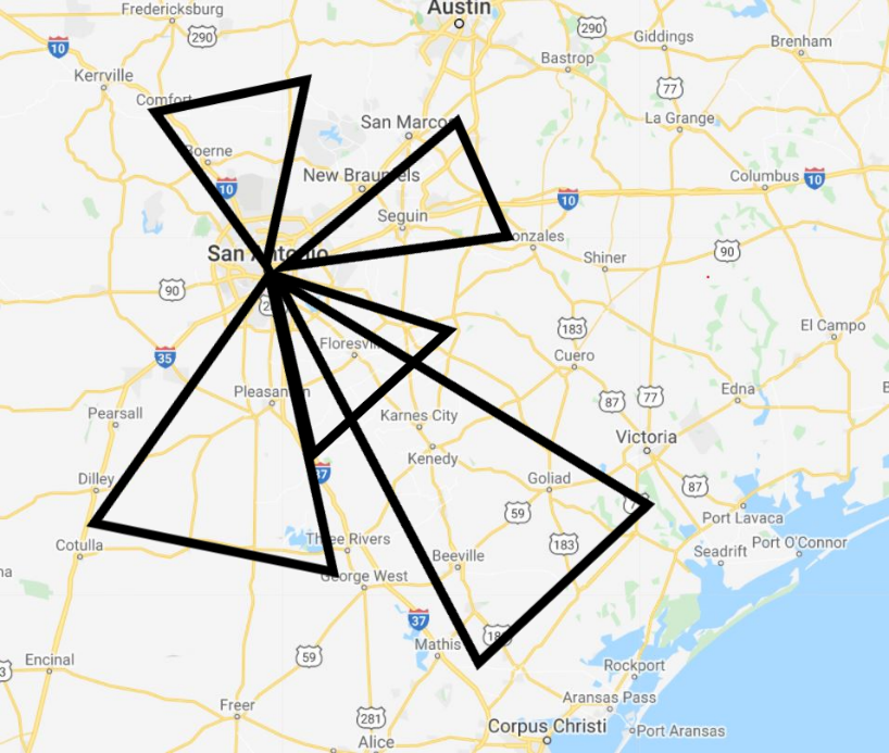
In the case of our work in San Antonio, the San Antonio Metropolitan Health District commissioned the Entanglement team and mobile lab to survey, map, and quantify ground-level ozone precursors around Bexar County, Texas – an area representative of over 1,200 square miles.
During our study, each day was spent with two members of the Entanglement team driving a route to transect the area around Bexar county, covering approximately 300 miles of terrain every day. Each trip was carefully planned in order to drive up- and down-wind of important features and installations in that day’s sub-region of Bexar county, so that we could estimate emissions from each “pie-slice” around San Antonio (see below).
By the end of our deployment, we had collected 3,000 miles worth of data that will help inform crucial public health decisions in the region for years to come.
Understanding from Sources to Measurements
Understanding the specific sources of ground-level ozone in the area could help protect and improve public health and reduce loss of life.
Unlike emergency response deployments, which are focused on hunting for narrow plumes of pollutants from individual sources, our goal for this survey was to characterize the emissions from a number of sources throughout an entire region. Using standard instrumentation, this would have been extremely difficult. Typical speciated VOC measurements require instruments such as GC-MS and GC-FIDs, which have been historically limited to in-lab operations. Recently, field GC-MS instruments have become available, but are difficult to use and acquire good data with, especially when on the move in a large survey such as this. Fortunately, large-scale, geographical studies are now possible due to development of new analytical techniques such as our AROMA, which allows speciated VOC data to be gathered in the field with minimal calibrations and method detection limits in the parts per trillion range.
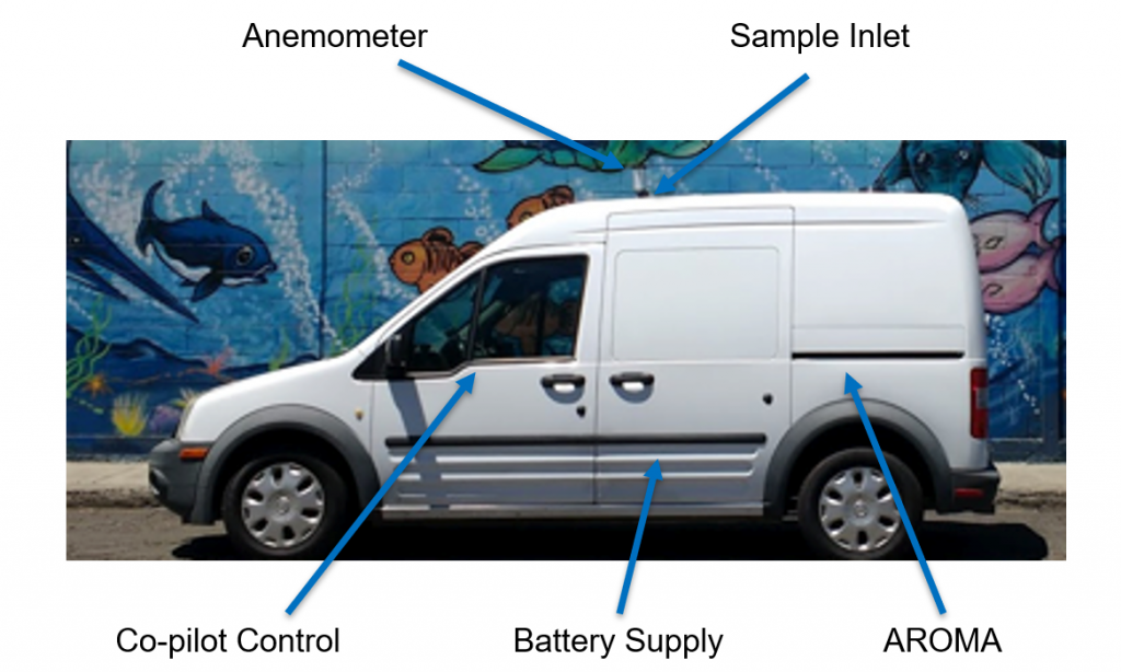
Our mobile monitoring laboratory (see below), had two Entanglement AROMA-VOC instruments collecting interleaved data and providing continuous coverage over the course of each day’s drive. The analyzers are equipped with onboard GPS, which allowed our team to localize the data from the precision NOx analyzer that was also installed in the lab. At the same time, our team’s route and map was constantly updated from a stream of meteorological and traffic data in order to optimize the data collection process and its usefulness.
We selected times early in the morning, often starting before 5am, and late at night, sometimes until 2am, to collect the data during low-traffic times when the sun would not be causing photochemical reactions or significant updrafts. The closer to midday, the stronger the sun and the larger the updraft of warm air that occurs, diluting the concentrations of chemicals in the air and interfering with accurate pollution measurements.
The San Antonio area has been experiencing high concentrations of ground-level ozone, with estimates suggesting that ground-ozone related deaths could cost the city upwards of $170 million. Understanding the specific sources of ground-level ozone in the area could help protect and improve public health and reduce loss of life.
For our fieldwork in San Antonio, the Entanglement team leveraged several past, fixed-monitor studies in order to pre-identify the most likely potential sources of VOCs and NOx in the region surrounding San Antonio. From those sources, we created custom routes that started in the city and branched out each day in different directions, allowing us to fully map the region in a matter of days.
Each route was optimized the night before the drive to ensure we drove perpendicular to expected wind fields and to minimize traffic, which was already minimized significantly due to secondary effects of the global health pandemic.
The AROMA instruments were able to sample the air continuously for VOCs with method detection limits below 5 parts per trillion by volume. While the primary goal was to cover as much ground as possible, we were also able to investigate specific targets flagged for us as potential sources of VOCs and NOx.
Transforming from Snapshot to Insights
The 10 days of data collection allowed the Entanglement team to create an accurate map of VOC and NOx concentrations in counties around Bexar County. The mobile monitoring solution provided significant and numerous benefits over traditional fixed monitoring approaches.
A mobile analyzer collects data that would require hundreds of fixed stations to collect, each one costing more than a single mobile study.
First, the data collected by the AROMA contains a wealth of information which would not be cost-effective to collect with fixed monitors. A mobile analyzer collects data that would require hundreds of fixed stations to collect, each one costing more than a single mobile study. The ability to vary data collection spatially, rather than only temporally, greatly increases the capability of researchers and regulators when looking to assess trends in their regions.
On the other hand, the downside of a mobile campaign is that it only captures a snapshot in time. However, for the purposes of understanding the key sources of precursors that contribute to the formation of ground-level ozone in a municipality, a mobile survey like this can provide the data needed for regulatory decisions to be made much quicker and for a much larger region than feasible with fixed sites. Additionally, mobile studies can be repeated semi-annually for further increasing the usefulness of the data, and for modelling trends and any effects of regulatory decisions on the dispersion and concentrations of ground-level ozone’s primary constituents over longer time periods.
The Entanglement team is currently working to complete the analysis on the data from our 10-day mobile survey. These results will be detailed in a forthcoming white paper. In the meantime, we are exceptionally grateful to the San Antonio Metropolitan Health District for the opportunity to collect data in service of improving the public health.
For more information, please contact us.
Entanglement Tech Featured in New Air Quality Case Studies
Comments Off on Entanglement Tech Featured in New Air Quality Case StudiesEntanglement Technologies advanced sensors were featured this month in two new case studies published by Stax and C40 Knowledge Hub.
In A Breath Of Fresh Air: A roadmap for investing in air quality sensing technologies to address climate, health, and air pollution, Stax highlighted Entanglement’s field work after Hurricane Harvey to identify potential contaminants in the region:
Working with local governments and rapid responders, Entanglement surveyed the region in two days to identify hot spots. They provided real-time data to local governments to issue alerts or evacuate areas as needed to protect the public.
C40 also highlighted this work with the Environmental Defense Fund in its report Mobile air quality monitoring in Houston after Hurricane Harvey:
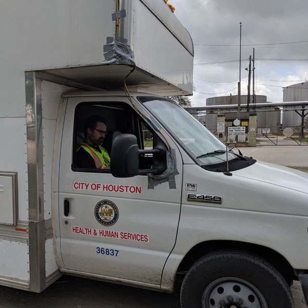
As regulatory monitors had been turned off by state air officials to protect the instruments from the storm, Houston had no information about potential exposures during and in the days following Harvey. To fill this data gap, the City of Houston Health Department dispatched a mobile air quality effort to record toxic hotspots. They found concentrations of benzene – a toxic carcinogen – of 38 times the threshold for an ‘acute’ exposure.
We are happy to see our work being shared to advance mobile sensing technology globally. Learn more about why it’s so important in our recent Medium post.
Editorial: Why Cities Need Mobile Environmental Sensing Tech to Stay Healthy and Prosperous
Comments Off on Editorial: Why Cities Need Mobile Environmental Sensing Tech to Stay Healthy and ProsperousThe air we breathe, the water we drink, and the soil under our feet — all share the legacy of chemical pollution. Many of the chemicals that have been and continue to be released can significantly impact human health and well-being. Unless we know exactly which chemicals have been released, exactly where there are, and exactly how they got there, it is enormously expensive to try to fix the problem. This is like trying to wash every dish you own every night because you can’t tell which dishes you used for dinner.
The traditional approach to understanding chemical pollution is top down: Companies count valves, junctions, tanks, stacks, pools, and hoods to estimate how much pollution they release. But where does it end up? With the advent of new sensing technology, it is now possible to perform true “bottom-up” pollution analysis based on real data collected in the places where it has an impact.
Traditional pollution detection is slow and imprecise
For decades, the only way to monitor most types of pollution was to collect a sample, ship it to a laboratory, and then wait days or weeks for the results. Worse yet, many of the harmful chemicals that are now top priorities for cleanup and monitoring were undetectable 20 years ago, which means scientists have barely had time to map the landscape for these pollutants.
What if technology could help us quickly pinpoint the polluters?
Without knowing what’s in the environment already or being able to quickly spot changes, our policy-makers are unable to make informed decisions, such as whether to keep home schoolchildren downwind from a wildfire or to temporarily close businesses near a factory explosion. Cities need high-quality, high-density data to identify which communities have the highest concentrations of chemicals and to educate them on how to be safe while pollution problems are addressed.
In addition to improving public health, identifying pollutants offers large financial benefits for a city. There are currently more than 1,300 superfund sites in the United States, for example, and an estimated 70 percent of cleanup costs have been paid for by the responsible parties. What if technology could help us quickly pinpoint the polluters?
New technologies are driving new insights
The past few years have seen an explosion in chemical and pollution sensors, driven by advances in laser physics, electro-optics, nano-scale fabrication, and computing and electronics. When combined with improved wireless communications, these technologies have created the conditions to change the way we collect and analyze pollution data — moving environmental sensing out of the lab and into the field.
Although many new chemical sensors can record data continuously, they still require high user touch to yield actionable data. Either sensors drift in response to external stimuli (like changes in humidity, temperature, or the alcohols produced by yeast at a local bakery) or require carefully prepared reagents. But a new-generation tools like the AROMA (an analyzer developer by my company) are delivering data that is sensitive and accurate over long timescales.
Some cities are already using new sensors
By deploying the AROMA technology, we have helped cities deal with large-scale chemical fires, hurricane damage, wildfires, and power interruptions that “crashed” petroleum refineries. In these cases, real-time analytics has been critical for making informed decisions about evacuations, shelter in-place orders, and allocating resources to respond when multiple facilities or locations have been impacted in a major event.
Our technologies have already been helping places such as Houston, TX, Redding, CA, and Lumberton, NC, respond to natural disasters. In addition, we have seen that cities like Houston have built out a multi-site monitoring network and are working to implement real-time tools like the AROMA analyzer to respond to emergency events like the ITC fire.
But this is only the first and simplest set of applications for high-quality chemical monitoring. We can now begin to answer questions ranging from sources of unpleasant odors, locations of clandestine drug laboratories, manufacturing outputs of chemical and food producers, the health of agricultural spaces, and identification of chemical leaks and spills before they lead to fires and explosions like the ones that we have seen recently in Houston.
We believe that environmental monitoring will become as integral to a city’s infrastructure as traffic lights and sensors.
Real-time environmental monitoring as part of city infrastructure
AROMA and similar technologies produce incredible data, but the datasets are not the ultimate goal of our work. We care about the kids who are kept home from school downwind of a fire, families who know not to drink contaminated water, or businesses that can stay open because a chemical release is not a severe as initially thought.
We believe that environmental monitoring will become as integral to a city’s infrastructure as traffic lights and sensors. When it is as easy to issue a citation for pollution as for speeding, we will see fundamental changes that will improve health for all. When we know exactly how and when facilities create pollution, society can design regulations that mitigate the harm with minimal impact on the businesses that are the lifeblood of modern cities.
Editorial: Making Outdoor Time Safer in Summer: Bringing Cutting-Edge Tech to Ground-Level Ozone
Comments Off on Editorial: Making Outdoor Time Safer in Summer: Bringing Cutting-Edge Tech to Ground-Level OzoneThe July 4th holiday weekend is peak time for families to be outside — grilling, watching fireworks and enjoy the summer. But the heat and sunshine work together to brew something dangerous in our air: toxic, ground-level ozone.
Unlike the ozone layer in the upper atmosphere that protects us from the sun’s harmful UV rays, ground-level ozone forms when heat and sunlight cause volatile organic compounds (VOCs) and nitrogen oxides react. These chemicals are in our atmosphere because of car exhaust, factory emissions, and even to some extent plant respiration. Ozone is an extremely reactive compound that, when inhaled, damages cells in the respiratory system, and can aggravate asthma, chronic lung disease, and a host of other respiratory illnesses.
At my company to detect chemicals in the environment, we believe that fast and accurate sensing technologies are the key to finding and fixing the sources of pollution. When people on the ground know where high concentrations of ozone come from, we can take steps to fix the problem and protect our community
A growing ozone crisis

Some groups estimate that ground-level ozone will cause $580 billion in increased health costs and 2 million premature deaths annually. Ozone hurts plants too, and one estimate puts to reduction in soy-bean harvest at $35 billion per year by 2030.
The key to solving this crisis to to identify and eliminate the sources of the chemicals that react to cause ozone. Major sources of VOCs in the atmosphere are cars and gasoline-burning engines. Among these VOCs is benzene, a known carcinogen that my team and I have become intimately familiar with in monitoring air quality conditions across the country. The sources of benzene are diverse. As byproduct of incomplete combustion, benzene is emitted by forest fires, ineffective catalytic converters on cars, and cigarette smoking, among other sources, and is a component in gasoline.
Major reductions in ozone have come with tighter pollution and vehicle emission controls, but progress has slowed in recent years. Although federal law has limited benzene concentrations in gasoline since 2011, gas stations and leaking energy plants can still emit high levels of the chemical, as my team and I saw firsthand last year.
The more we understand the sources of pollution, the better we can be at fixing them.
That is part of why environmental authorities recommend waiting until after dark to pump gasoline in the summer. By limiting the leaking of benzene and other chemicals from gas nozzles, it limits the formation of ground-level ozone.
Closing in on solutions
So what else can we do to address this challenge?
The more we understand the sources of pollution, the better we can be at fixing them. If communities know where pollution is coming from, they can decide how much we want to spend on reducing pollution and how much they want to spend on health care costs.
Pollution is an issue that often looks like many of the problems we encounter in society: a few “bad actors” often account for a huge fraction of the cost. This is true for cars and large-scale polluters. But because we have traditionally lacked the tools to perform granular measurement on the ground, we haven’t been able to target the small set of worst-case polluters.
This is where technologies like our AROMA instrument come into play. We are now able to quickly survey large areas with extraordinary sensitivity to identify and quantify sources of pollution. Because different chemicals have different reactivity, it is critical to characterize exactly which chemicals are being released by any polluter. Tools like AROMA that provide immediate, multi-chemical analysis are giving us, for the first time, the ability to quickly and definitively identify where pollution is coming from so that we can better protect people.